Hickory Run State Park is an alluring spot with its waterfalls, boulder field, and a plethora of hiking trails offering scenic views. In fact, outdoor fun abounds at this dog-friendly park in eastern Pennsylvania, in the foothills of the western Pocono Mountains. There are almost 16,000 acres and over 40 miles of hiking trails plus fishing, camping, swimming, birdwatching…and more. The park is located one hour from Allentown and Scranton, 1.75 hours from Philadelphia and Harrisburg, and 2 hours from New York City. (It’s close to where Routes 80 and 476 intersect in White Haven.)
Some of the top experiences while visiting are:
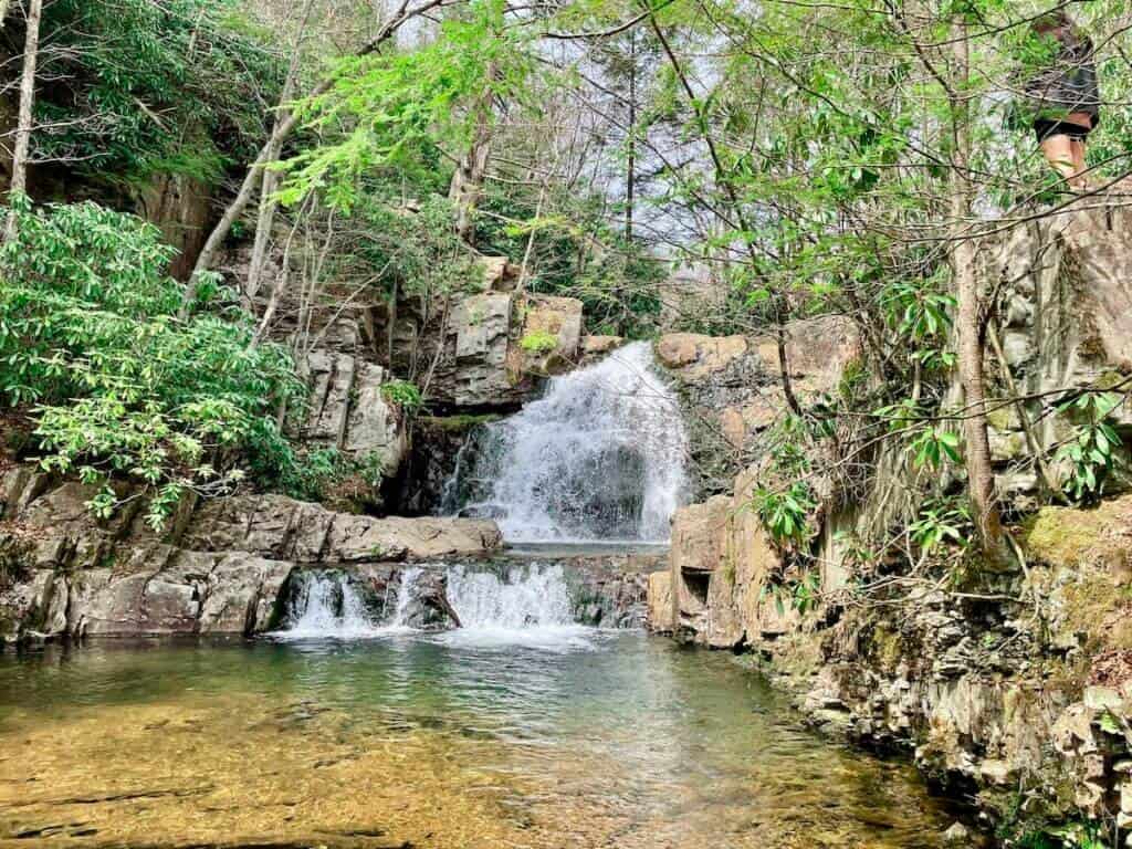
Hawk Falls
This heavily trafficked one-mile out-and-back trail will treat you to a lovely 25-foot natural waterfall. You will cross a wooden bridge and walk through a tunnel of rhododendron shrubs. It’s an easy stroll and is accessible at the trailhead along Route 534, just east of Route 476 (you’ll be able to see the overpass). There’s parking available on both sides of Route 534 by the trailhead, and the trail begins on the southern side of the road. The trail takes you to Mud Run, you’ll bear right, and end up at Hawk Falls.
If you want to extend your hike, consider taking the 3-mile loop Orchard Trail (with a trailhead that you’ll pass near Mud Run while walking to Hawk Falls); this other trail is more difficult because of the uneven terrain but passes through woodland with some water views.
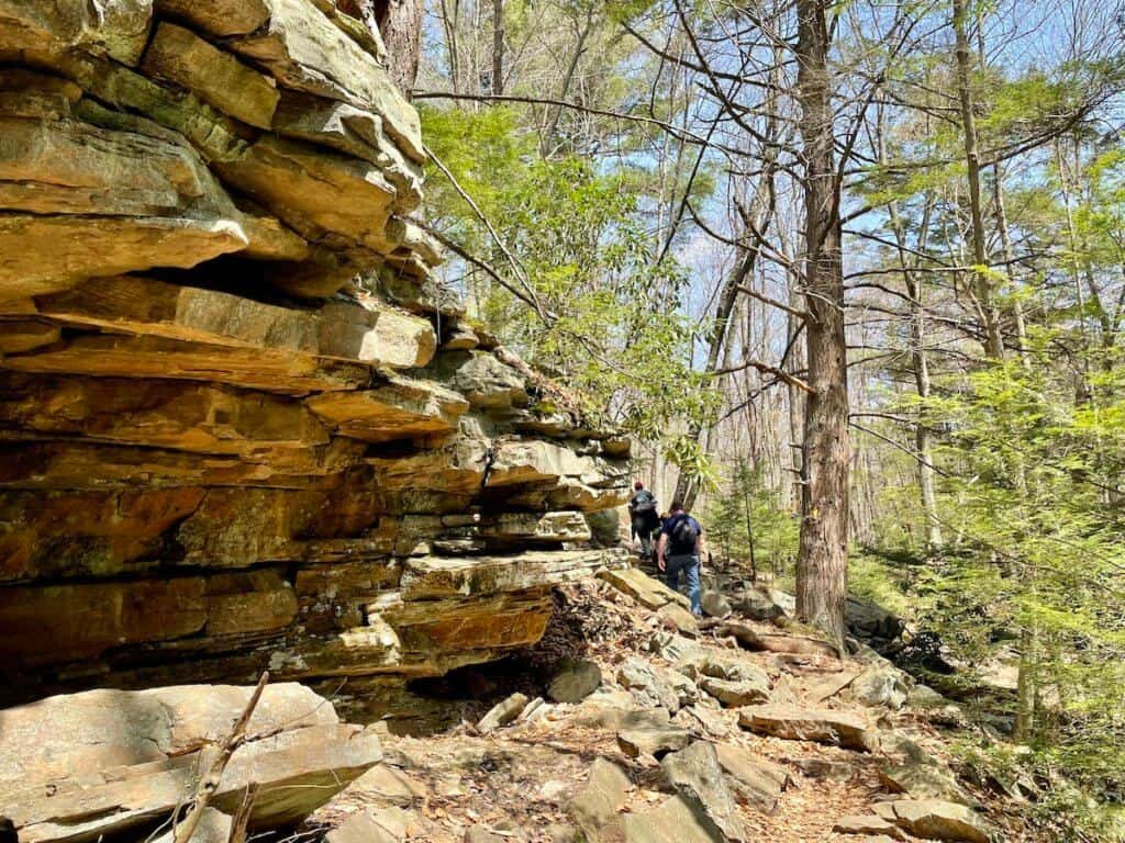
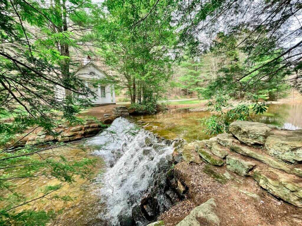
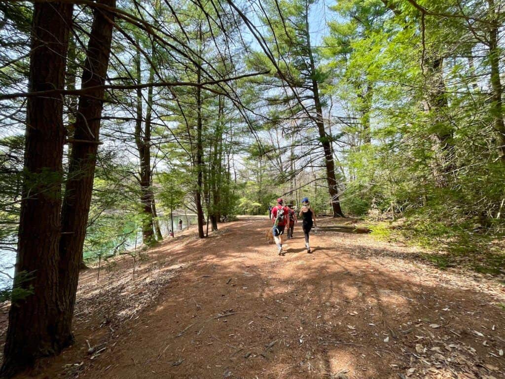
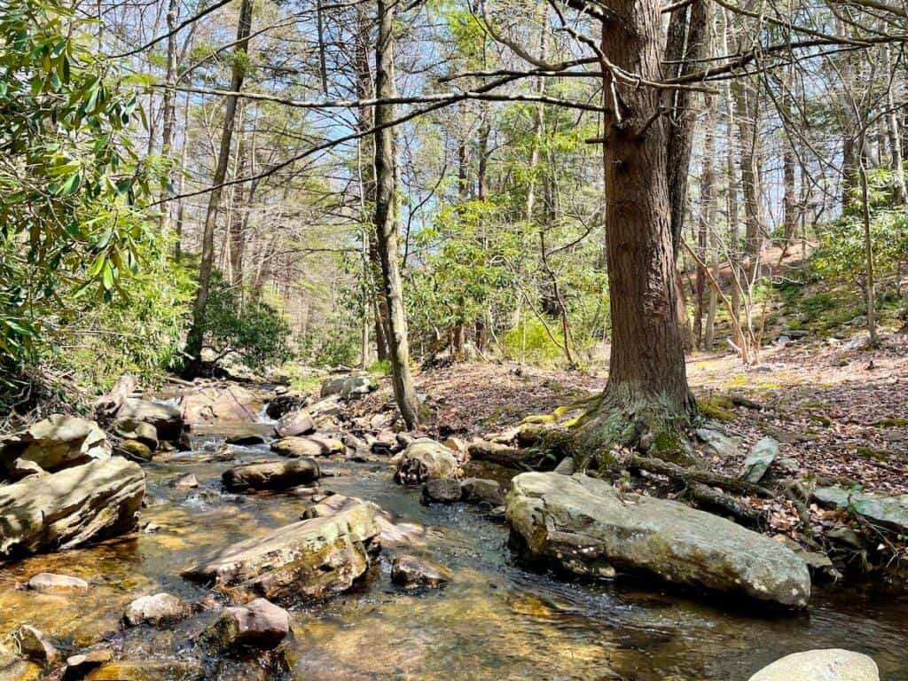
Shades of Death Trail
This popular 2.2-mile out-and-back trail hugs Sand Spring Run, a creek, and has several scenic spots including waterfalls (resulting from man-made dams). You can pick up the trail near the visitor center or park along Route 534 by the chapel (see map below).
Expect rocky terrain with some tree roots, but it is not a very difficult trail. Don’t let the name of this trail spook you! Early settlers named this area Shades of Death because of the dense forest, swampy land, and rocky terrain that made it difficult to live there. (My hiking poles came in handy on this trail due to the uneven ground.)
My husband and I brought along a picnic lunch, and we enjoyed it along this trail. We found some creek-side boulders to sit upon and listened to the sweet sound of water rushing by while we ate. Please note that if you bring food with you, you must take out all your trash. Do not expect to find trash bins along the trails.

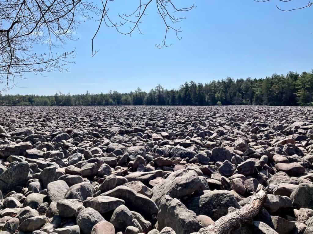
Boulder Field
This 16-acre field is filled with boulders that are a result of the freezing and thawing of rock over 20,000 years ago. In fact, it is a National Natural Landmark. It is definitely a sight to see and can be reached by taking the Boulder Field Trail (a little over 6 miles on an out-and-back trail) or by driving along Boulder Field Road (a mostly one-way road filled with ruts: go slowly!).
Old Chapel
Dating to the 1800s, this white chapel stands by Sand Spring Run, a creek (and very close to a parking lot). It is accessible from Route 534 by Stametz Dam and is also a trailhead for the Shades of Death trail. So you can hike here (starting near the visitor center) or park here. If you’re hiking on other trails, you might want to drive here if you enjoy scenic views and history. There are also remains of some logging mills along this trail.
Admission
- FREE 😃
- Your leashed dog is welcome to join you. 🐶
What You’ll Find at Hickory Run State Park
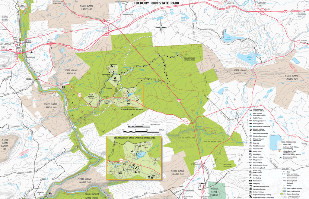
- over 40 miles of trails. There are 25 trails listed on the trail map and range from .4 miles on easy terrain to about 5 miles on more uneven ground. Which will you choose?
- visitor center with maps, a wildlife exhibit, and restrooms.
- campgrounds with related amenities (i.e. showers, restrooms, electric hookups)
- picnicking areas and playground in the Day Use Area
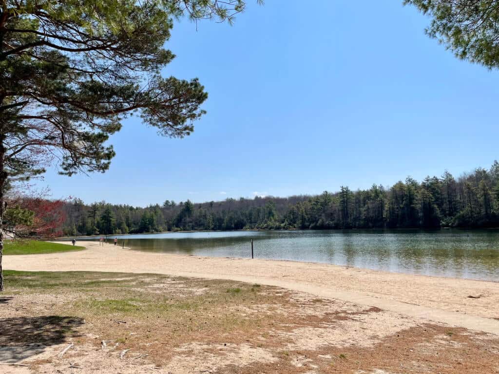
- beach and swimming area at Sand Spring Lake with snack bar and restrooms during the season, late-May to mid-September.
- fishing in the streams and lakes.
- disc golf course.
- hunting, trapping, and training of dogs in the hunting areas (during the season).
- geocaching.
- orienteering courses.
- winter sports options including cross-country skiing, snowmobiling, and ice skating.
- no biking trails.
Location
Hickory Run State Park, 3613 State Route 534, White Haven, PA
Park Map
Tips for Your Visit
- The park is open from sunrise to sunset.
- Arrive early on the weekends to beat the crowds. Fewer people make your time there more enjoyable.
- The visitor center has detailed trail maps and someone to help guide you to where you want to go. But you don’t need to go to the visitor center to enjoy the park. There are many trails to enjoy and you’ll find trail information online; some trailheads (like Shades of Death) are near the visitor center while others are located along Route 534. So many options!
- Consider using hiking poles, if you have them, because of the uneven terrain on several of the trails.
- Using the All Trails (free) app can help when choosing a trail and while you’re hiking to see where you are relative to your parked car or other trails.
- Cell phone access is spotty. Before setting out on a hike, take a picture of a map on your cellphone for later reference — or bring along a paper map.
- Wear sunscreen and bug spray.
- Wear comfortable walking/hiking shoes.
- Bring plenty of water (plus maybe snacks and/or a picnic). There are no concession stands along the trails.
- Depending on the weather, you may want to dress in layers so you can peel one off as you warm up — or add a layer when the day turns cooler.
- Restrooms are located at the visitor center. There are no facilities on the trails, although some other restrooms in the Day Use Area are open during the summer season.
- Stay on the trails.
- Plan to take your trash with you when you leave.
- No alcohol is allowed.
Brief History of Hickory Run State Park
Native Americans were the first inhabitants of the land. In the late 1700s, settlers arrived when land grants were given out. Later, in the 1800s, the Lehigh Canal and a stagecoach line were established and lured visitors to the area. In the early 1900s, General Harry Trexler purchased land here to create a public area for fishing and hunting. A few years afterward, the National Park Service bought the land. Then beginning in the 1930s, the Works Progress Administration and the Civilian Conservation Corps, two federal public works programs, built roads and trails and made other improvements. In 1945, the land was transferred to the Commonwealth of Pennsylvania and became a state park.
Hawk Falls and Hawk Run are named after the Hawk family who farmed on nearby property. By the way, you’ll notice that the creeks are called “runs” which is a term once used for such bodies of water.
Final Thoughts
My husband and I thoroughly enjoyed our visit to Hickory Run State Park. There are so many trails to choose from that you’re bound to find one — or a few — that fit your interests. I am a sucker for bodies of water (I can’t get enough of the calming feeling I get when I’m around them) and really liked the Shades of Death trail that hugs Sand Spring Run and featured waterfalls. Hiking on several of the trails — including a delightful picnic lunch on some boulders in the creek — was doable on a day trip.
A Note about Boulder Field
Besides the trails along the creek and the waterfalls, I’m happy that we made it to Boulder Field. I made a slight mistake, however; I wanted to find the trailhead to Boulder Field, but instead, my trusty Waze app sent us by car directly to Boulder Field! The road there was filled with ruts, so it was a slow drive as my husband did his best to navigate our car around them. Once we realized what was happening (driving there as opposed to hiking on the trail), it was too late because we were on a one-way road and couldn’t turn around. As it turned out, though, this mistake actually worked in our favor. Because we took the “shortcut” to Boulder Field by driving there, we had more time to explore other trails afterward.
Nearby Attractions
There are lots of places to enjoy in Pennsylvania. Here are some other ideas:
- Bethlehem, PA: A City Where History and Reinvention Meet, Lehigh Valley
- Big Pocono State Park, Poconos
- Bushkill Falls, Poconos
- Covered Bridge Tour of Bucks County
- Covered Bridge Tour of the Lehigh Valley
- Gettysburg Visitor Guide
- Hawk Mountain Sanctuary, Lehigh Valley area
- Housenick Park, Lehigh Valley
- Jacobsburg State Park, Pocono area
- Museum of the American Revolution, Philadelphia
- National Museum of Industrial History, Bethlehem
- Philadelphia Self-Guided Walking Tour
- Best Things to Do in Philadelphia
- Pittsburgh and Southwestern Pennsylvania Guide
- Promised Land State Park, Poconos
- Ricketts Glen State Park, Poconos
- Tyler State Park, Bucks County
- Valley Forge National Historical Park, outside Philadelphia
- Washington Crossing Historic Park, Bucks County
Comments?
Please share your experiences and/or suggestions for fun outdoor spaces in eastern PA. Your ideas could be helpful to other travelers. Thanks! 🙂